![[]](https://www.tanzaniaparks.go.tz./uploads/banner/large_1583321674-banner.JPG)
News


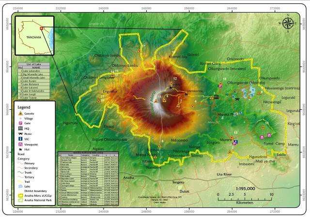
Arusha Meru Geopark
e Arusha-Meru Geopark
Description of Geological Heritage Sites:
The geosites of the Arusha Meru Aspiring Geopark are associated with the collapse of Mt. Meru and the resulting geomorphology of the area which demonstrates how geological process has shaped the landscape, ecology and culture; and conveyed the history of the earth and created scenic areas for enjoyment as well warns the community about any possible geohazard relating with volcano eruptions, tectonic activities and landslides. Among the geosites are Mt Meru Peaks, volcanic ash cone, waterfalls, lakes, debris avalanche deposits (DAD), lahar, parasitic cones and craters.
The Mt. Meru; The dominant feature of the Aspiring Geopark is Mt. Meru, the astonishing free-standing stratovolcano mountain with three unique scenery distinct peaks (Big, Little and Ash Cone) developed at different geological times. It stands at 4565m high on the Meru plateau, which makes it the second tallest mountain in Tanzania, after Mt. Kilimanjaro and fourth in Africa. The mountain is characterized by the most spectacular horse-shoe-shaped scar caldera resulting from the eastern wall collapse due to unconsolidated volcanic materials. These visually striking and colourful geologic features of the peaks and ash cone create a dramatic breathtaking landscape that provokes introspection. Mt. Meru has a diameter of about 25 km. The last known, ash eruption of Mt. Meru dates from 1910. The 1,300m high near vertical internal walls on the western face expose numerous layers of lavas and ash deposits, as well as evidence of block faulting, and feeder dykes.
Trekking to the summit is not only a safari adventure and acclimation for climbing Mt. Kilimanjaro, but scientific and educational safari as different volcanic rock types, depositions, structures, springs, waterfalls, dykes, and landscapes can be observed along the way.
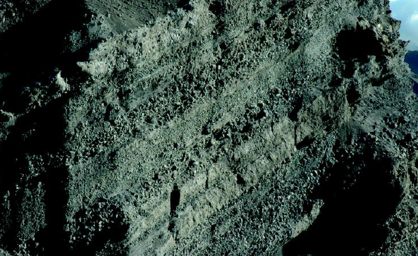
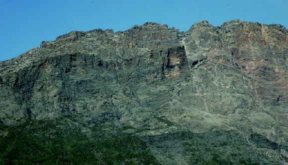
Figure 2: Layered deposition of ash, lava, and pyroclastic materials as observed on the scar walls of Mt. Meru.
The Little Meru
Little Meru is the monogenetic volcanic cone rising to an elevation of 3800m northeast of the main Meru cone. Due to its closeness to Meru main cone, its southern slopes have been buried by the erupted lava which makes it the easiest way to reach Mt. Meru highest peak. The peak of Little Meru provides a scenic view to the north as far as Mt. Oldoinyo Lengai.
Mt. Meru “Socialist Peak”
The highest peak of Mt. Meru and the second generation of the Meru stratovolcano mountain. The summit was formed by a 150 m high rock dome. The Socialist Peak has a clear and near view of Mt. Kilimanjaro with a triangular shadow during sunrise. Trekking to the summit gives an experience of a lifetime of the link between geology, culture and wildlife.
The Ash Cone: The ash cone is a pyramid-shaped ash and cinder cone 1.5 Km wide, rises up about 200m above the crater floor, characterized by dark ash and vesicular pumiceous blocks up to 30cm in diameter. At the western base of the ash cone is a nephelinite lava dome, which is 350 m in diameter and 70 m high. Numerous later lava flows originated from the lava dome and flowed down the collapse scar extending up to a 7 km distance.
The view from Mt. Meru “Socialist Peak” or distance might provide the best view to exploring the scenic beauty of the ash cone which was once used on the cover book “Geology of National Parks of Central/Southern Kenya and Northern Tanzania” by Roger Scoon.
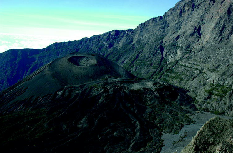
Figure 3: The ash cone as viewed from the summit ridge of Mt. Meru. Gently dipping layers of well-bedded lavas on the western wall of the Mountain (Picture by Roger Scoon).
Momella DAD
Momella Debris Avalanche Deposit (DAD) is considered the largest DAD recorded for a continental volcano on earth comparable to the collapse of Mt. Socompa, Mt Shasta, and Mt St Helena. The deposits spread eastward to the base of Mt. Kilimanjaro forming a hummock shape, rounded or elongated along an axis perpendicular to the spreading direction, composing homogenous and heterogenous materials. Hummock forms large hills (shear zones) approximately 100m high around Momella Lakes but reduced to a smaller size as you go far from Momella. Some of the hummocky terrain was created, was later occupied by the Momella Lakes, ponds, and marshes.
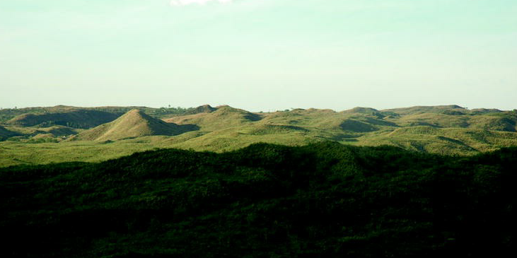
Figure 4: Hummock terrain of the Momella DAD on the lower slope of Mt. Meru.
Tululusia waterfalls
The waterfalls are one of the major tourist attractions in the aspiring Geopark and the most visited site.The falls are about 28 meters (84ft) high cutting the soft rock of debris material deposited during the debris avalanche. Debris material was being eroded by water leaving behind a gorge (narrow-sided valley). The steep gorge walls provide nesting sites for Red-winged Starlings.

Figure 5: Tululusia Waterfall, one of the most accessible and famous geosites in Arusha-Meru Geopark. The walls dispose of different deposition facies related to Momella DAD
Ngurdoto Crater
Ngurdoto and Meru craters are peculiar geological features that support evidence of volcanic activity and have a historical significance since the park started as Ngurdoto National Park. The Ngurdoto volcano, which is now extinct, has a classic summit crater measuring about 4×3km with a depth of 360m. From the pear shape of the present-day crater it seems that towards the end of its activity, there were two cones lying very close together. When the molten rock below the cones withdrew to deeper lavas, the cones were left without support. They then collapsed forming the present crater, or more properly, a caldera, just like a miniature Ngorongoro. The bottom of the crater is at an altitude of 1474m and has permanent water and good grazing pasture, making the place a safe reserve for buffaloes. The area forms an important habitat for wildlife since it is evergreen throughout the year.
Momella Lakes
The Momella Lakes are perennial alkaline lakes, located north-eastern of the geopark area, on the hummocky landscape associated with Momella debris avalanche deposits. They are important stopovers for a large variety of birds that migrate between Europe, East Africa and Southern Africa.
The Momella Lakes include three large lakes charged by underground streams, and smaller lakes, ponds and marshes. Although they are formed in the same deposit, Momella lakes differ in chemical composition and alkaline concentration. Big Momella Lake measures 10 – 30M deep, with moderate alkalinity. Small Momella, considered a scenic lake, is shallow, measuring 4-10m deep with alkaline and salty in the central parts while some section includes freshwater from an underground river system, in which Hippopotamus and aquatic birds thrive. Rishateni Lake is an unusually small lake rich in the concentration of dissolved fluorine derived from the erosion of the alkaline-rich volcanic rocks, possibly the highest ever recorded in natural lakes.
The differences in mineral contents of each lake support a different type of algae growth and give each a different colour.
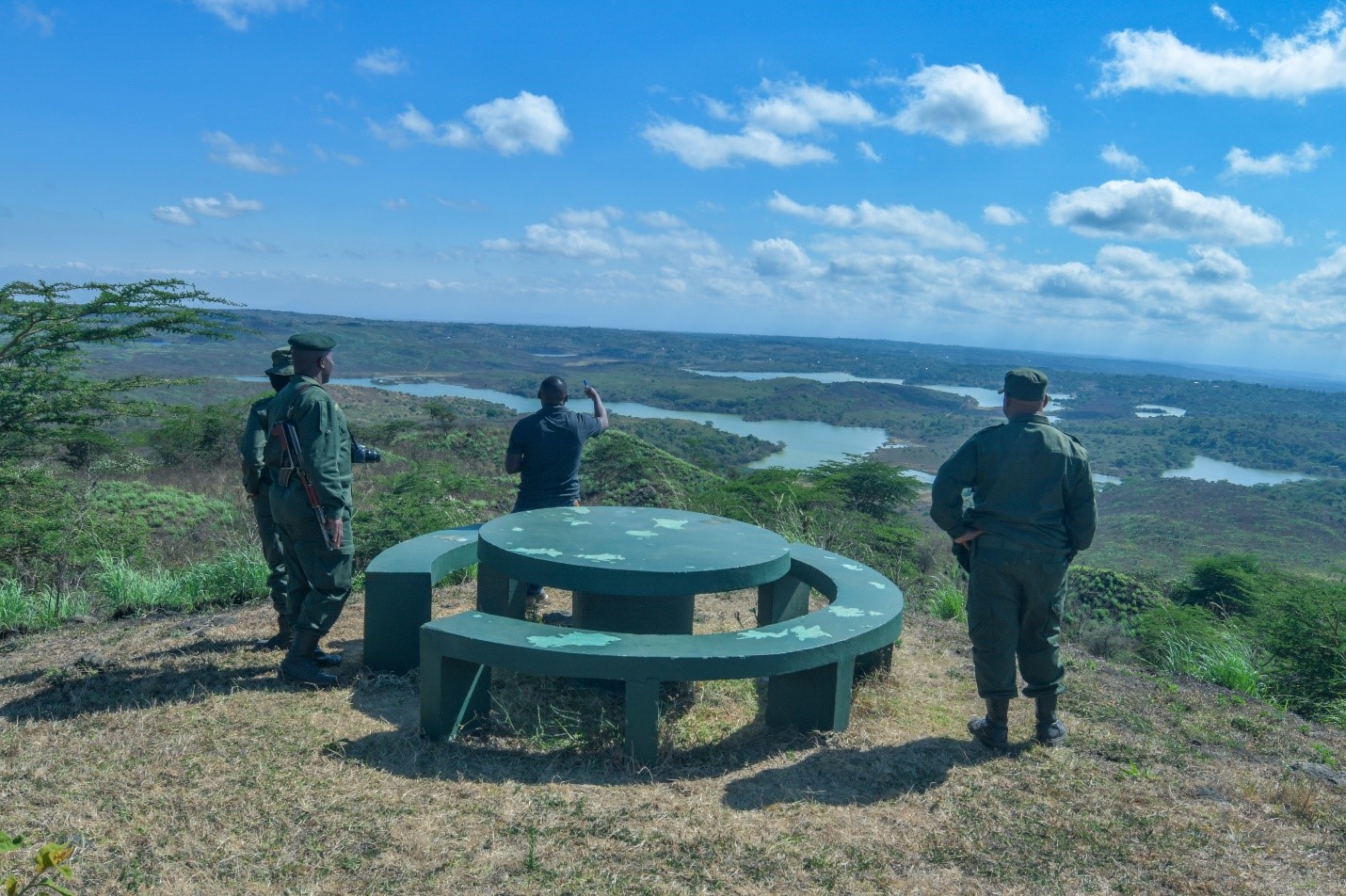
Figure 6: Momella Lakes from a view point.
Maio Waterfall
This is a three steps waterfall running on the basaltic rock, flowing from the eastern slopes of Mt. Meru. The first fall head is 10 deep, then runs on the flat stunning surface for 20m before falling approximately 14 m, and running the final third for almost 50m to create the waterfall in the Ngarenanyuki River.
Description of Sites of Natural, Cultural and INTANGIBLE Heritage
Habitat Diversity
The Arusha-Meru Aspiring Geopark contains a remarkable diversity of habitats in a small area, ranging from open glade to Montane Forest, heath and moorland, primary and secondary vegetation, from freshwater to strongly alkaline lakes and swamps. Microhabitats and different climates present, create an unusual species mix, including lichens, molds, and endemic species that are highly visible examples of the scientific concepts of succession and adaptation.
Due to this variety of habitats, the aspiring geopark serves as an ecological refuge of diverse species of flora and fauna, with relatively undisturbed remnants of dwindling ecosystems.
Serengeti Ndogo
Serengeti Ndogo, the name that means ‘‘Little Serengeti’’ is the most prominent and one of the first sightings for visitors entering the Arusha Meru Geopark through Ngongongare Gate. With its low grass pasture, the glade offers grazing pasture and supports a variety of grazers during the whole year. Serengeti Ndogo is the only area within the geopark where it is possible to see large groups of zebras, buffalo herds and other wildlife species such as warthog, bushbuck, giraffe, hyaena, waterbucks, reptiles, amphibians and birds.
One of the peculiarities of the aspiring geopark is the spectacular view of giraffe throughout the area. Due to the good number of animals and the mountainous terrain, it is easy to spot giraffes from many points of the geopark. Another peculiarity that attracts visitors is that giraffes are usually considered savannah animals, while here they are present in a mountain forest area, providing a nice view of their long necks among the tall trees.
The Arusha-Meru aspiring Geopark has a high habitat variety, which supports a high species diversity, of which the most attractive are butterflies and birds. Among the most beautiful and interesting butterflies, which can easily be seen include, the mother of pearl (Salamis parhassus), various swallowtails like the regal swallowtail (Papilio rex), the mocker swallowtail (papilio dardanu) and the rare papilio sjostedti in Kitoto area. The Nymphalidae are well represented, with the African monarch (Danaus chrysippus) quite common to see on Ngurdoto–Momella road. Banana bait (Chraxes candiope) is present in ANAPA and tends to be eaten by monkeys. There are three species of red admirals, two with fine tails. The ubiquitous painted lady (Vanessa cadrvi) is present high on the mountain. African clouded yellow (Colias electo) and the shell copper (Lycaena phlaeas) are isolated on the mountain. One of the most beautiful but rarely seen butterflies is the Gold-banded forester (Euphaedra neophron violacea) with iridescent purple wings, found in the deep forest.
With its many swamps, ponds and lakes, ranging from fresh to strongly alkaline water, Arusha-Meru Aspiring Geopark supports a great variety of about 500 species of birds.
Endemic species of Flora and Fauna
The aspiring Arusha-Meru Geopark supports numerous rare and endemic plant and animal species. The majority of endemic species belong to the Amphibia and Reptilia classes. Endemic amphibians are Hyperolius viridiflavus ommatostictus, endemic to the Kilimanjaro and Meru areas and Mount Meru Rana fasciata merumontana (Strongylopus fasciatus merumontanus) which is endemic in the uplands of northern Tanzania (Mount Meru, Uluguru and Usambara Mts).
Endemic reptiles are Chamaeleo jacksonii merumontanus, strictly endemic to Mount Meru. Bradypodion tavetanum is a relict species found on Teita Hills (Kenya), the Arusha area, Kilimanjaro and south to North Pare Mountains (Tanzania). Chamaeleo rudis sternfeldi forms a relict population on Mount Kilimanjaro and Mount Meru. Among the mammals, the white and black colobus (Colobus guereza caudatus) subspecies are found in East African Mountains only. Four flora species are endemic: Isolepis meruensis (Cyperaceae), Vepris arushensis (Rutaceae), Aloe ngongensis (Liliaceae), and Myatenus richardsine (Liliaceae).
Magic Fig Tree Arch
This Fig tree has been formed by the strangling habits of the fig tree Ficus thonningii. Seeds of the tree dropped by feeding birds in the form of a host tree, germinated and put out aerial roots. The roots reached the ground, slowly strangling the host tree that died leaving the fig replacing it. The unusual tree formation suggests that two host trees were present on either side of the road before the fig tree smothered them. The aerial roots in the centre of the Fig Tree Arch are prevented from filling in the opening by elephants browsing, nowadays car passages.
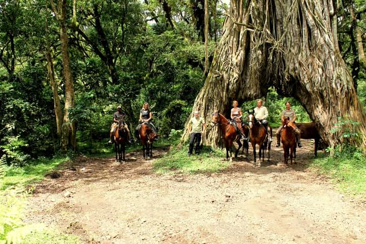
Figure 7: Fig tree arch
Tropical Montane Forest
The montane forest surrounding Mount Meru is an important water catchment, providing a stable water supply for irrigation, household use and hydroelectric power to the surrounding area, the surrounding communities, and Arusha town up to the Pangani basin. The montane forest is also very important to prevent soil erosion, flood damage and drought, to improve soil quality, to moderate temperature and serve as a windbreaker.
The tropical forest contains dry montane forest between 1500 and 2600 m a.s.l (Juniperus procera, Olea europaea subsp. africana, Podocarpus falcatus); montane forest between 1500 and 2400m a.s.l (Albizia gummifera, Nuxia congesta, Croton macrostachyus, Olea capensis, Ficus thonningii); upper montane forest with bamboo thickets between 2300 and 2700m a.s.l and Hagenia abyssinica between 2600 and 3000m a.s.l forming the forest line. The montane forest contains some very valuable timber trees such as Loliondo, East African Cedar, Podo, Olea and Entandophragma excelsum and contributes significantly to the overall biodiversity of the geopark.
Njekukumia Spring; Is a sacred spring to Meru people that were drinking the water for purification. The spring is especially used by women willing to have children, who were going to the spring early in the morning to drink and bathe from the warm water flowing from the spring.